Starting from the northwest along I-15 heading southwest till about Glendale NV.
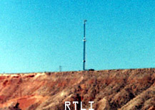
A local company relay tower located at the banks of the Virgin River, about a mile and a half from the border.
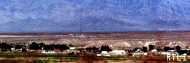
A cell phone tower just south of Mesquite...
Company: Southwestco Wireless Limited Partnership
Location: BUNKERVILLE,NV
Registration ID / Type: 1055322 / MAST
Longitude: 114.1328 (114D 7M 58S)
Latitude: 36.7639 (36D 45M 50S)
Directions: 885 RIVERSIDE ROAD
Elevation/Height: 493.5 / 44.2 meters, 1619 / 145 feet
![]()
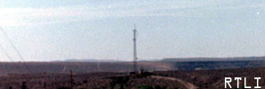
A weird looking tower! It is an FAA Vortec communications site. This tower is for military and civilian airplane navagation. I'm not sure about it but I think its on 114.300 mHz. This tower may be known as Mormon Mesa VORTAC, and the coordinates I speculate are right around 36-46-09.404N 114-16-38.892W. The previous cell tower is also in this picture
Another celltower for coverage in Mesquite and partial areas of Overton (frindge)
Company: AT&T WIRELESS SERVICES INC
Location: BUNKERVILLE,NV
Registration ID / Type: 1011140 / POLE
Longitude: 114.2525 (114D 15M 9S)
Latitude: 36.7625 (36D 45M 45S)
Directions: SW OF I-15 &
Elevation/Height: 598.0 / 27.4 meters, 1962 / 89 feet