Idaho Falls/Roberts/Hamer/Dubois/Spencer Idaho.
Back to
ID
Back
to RTLI
Starting from the south (of Idaho Falls) and
heading north on I-15, we see the following towers.
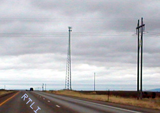
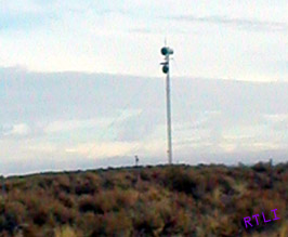
Company: NewCom
Wireless, LLC
Location: Blackfoot,ID
Registration ID / Type: 1218727 /
TOWER
Longitude: 112.2898 (112D 17M 23S)
Latitude: 43.2843 (43D 17M
3S)
Directions: City of
Elevation/Height: 1386.8 / 28.9 meters, 4550 / 94
feet
There are three towers in
this picture, two of which you can see, and one that is way in the distance.
From left to right we have...
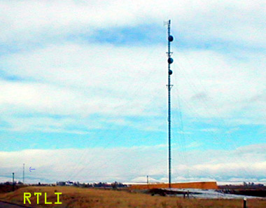
Company: Bonneville County, IDAHO Location:
IDAHO FALLS,ID
Registration ID / Type: 1203264 / TOWER
Longitude:
112.0524 (112D 3M 8S)
Latitude: 43.4946 (43D 29M 40S)
Directions: 1241
HOUSTON AVE
Elevation/Height: 1452.0 / 21.0 meters, 4764 / 68 feet
GoldenState Towers, LLC
Center
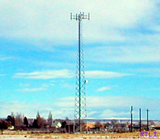
Company: Bonneville County Idaho
Location: idaho falls,ID
Registration ID / Type: 1212606 / TOWER
Longitude: 112.0412 (112D 2M 28S)
Latitude: 43.4951 (43D 29M 42S)
Directions: 605 no. capital
Elevation/Height: 1448.0 / 41.1 meters, 4750
/ 134 feet
Teton Communications Inc (2)
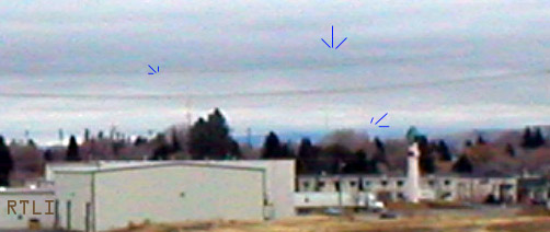
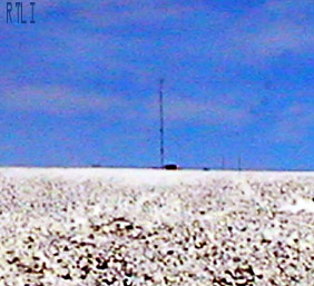
Distant towers
KUDI
AM,
KICN AM,
KIFI FM
KUPI AM,
United States Celluar
Corporation,
Golden State Towers.
American Tower l.p,
Idaho 6 - Clark
Limited Partnership
Relative location..Longitude: 112.0125 (112D 0M 45S)
Latitude: 43.5139 (43D 30M 50S)
ROBERTS ID
Company: American Tower
Limited Partnership
Location: Idaho Falls,ID
Registration ID / Type:
1211033 / TOWER
Longitude: 112.0839 (112D 5M 1S)
Latitude: 43.6115 (43D
36M 41S)
Directions: Bonneville County
Elevation/Height: 1468.1 / 81.9
meters, 4816 / 268 feet
Exit 143 I-15
These two towers are located right
at exit 143 on I-15 if you haven't already guessed. They are,
left...
Company: IDAHO 6 - CLARK LIMITED PARTNERSHIP
Location: MENAN,ID
Registration ID / Type: 1062727 / TOWER
Longitude: 112.1958 (112D 11M
45S)
Latitude: 43.8267 (43D 49M 36S)
Directions: 650' W I-15, 1500' S OF
INTERSECTION I-15 & ST. HWY. 88
Elevation/Height: 1490.5 / 93.9 meters,
4890 / 308 feet
Right
Company: Edge Wireless, LLC
Location:
Menan Butte,ID
Registration ID / Type: 1235290 / TOWER
Longitude:
112.1962 (112D 11M 46S)
Latitude: 43.828 (43D 49M 40S)
Directions: Town
of Menan Butte
Elevation/Height: 1490.5 / 57.3 meters, 4890 / 188 feet
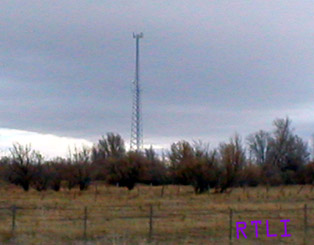
Hamer
Company:
United States Cellular Corporation
Location: HAMER,ID
Registration ID /
Type: 1040319 / TOWER
Longitude: 112.2056 (112D 12M 20S)
Latitude:
43.8986 (43D 53M 55S)
Directions: INTER. OF STATE ROADS 245E. & 1900 N.
Elevation/Height: 1461.5 / 94.5 meters, 4795 / 310 feet
There are two towers in this
picture, the other one is bottom left. Both
registered.
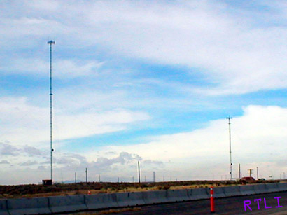
Right
Company: SpectraSite Communications, Inc.
Location: Hamer,ID
Registration ID / Type: 1228117 / TOWER
Longitude: 112.2075 (112D 12M 27S)
Latitude: 43.9216 (43D 55M 17S)
Directions: 2071 A North Old Butte Highway
Elevation/Height: 1461.8 /
91.4 meters, 4796 / 299 feet
Left
Company: Corban Towers, Inc.
Location: Menan,ID
Registration ID / Type: 1224086 / TOWER
Longitude: 112.1969 (112D 11M 49S)
Latitude: 43.9419 (43D 56M 30S)
Directions: 2504 East 2200N
Elevation/Height: 1465.5 / 24.4 meters, 4808
/ 80 feet
Dubois
Company: SpectraSite Communications,
Inc.
Location: Dubois,ID
Registration ID / Type: 1229063 / TOWER
Longitude: 112.2368 (112D 14M 12S)
Latitude: 44.1673 (44D 10M 2S)
Directions: 1430 N. 3800 East
Elevation/Height: 1562.2 / 45.7 meters,
5125 / 149 feet
Spencer
(CONFIRMED) Company: IDAHO 6 -
CLARK LIMITED PARTNERSHIP
Location: SAINT ANTHONY,ID
Registration ID /
Type: 1059450 / TOWER
Longitude: 112.1711 (112D 10M 16S)
Latitude:
44.3656 (44D 21M 56S)
Directions: 0.9 MI EAST OF INTERSTATE 15 AND 6.8 MI
NNW OF BED SPRINGS BUTTE
Elevation/Height: 1953.8 / 57.9 meters, 6410 / 189
feet
END! YEAHH!